This function opens a dialog window for the user to select which variables in the shapefile should be aggregated and to what minimum and maximum values. The dialog window looks like this.
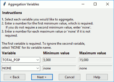
Figure: Dialog to select your aggregators
Select your desired aggregation variables. If you do not want to include a second aggregation variable, select "NONE". Enter your desired minimum and maximum values in the relevant boxes. Then click on one of the following buttons.
Click
Nextto continue to the next step.Click
Cancelto end GAT.Click
Backto return to the previous step.Click
Helpto get further guidance and open the manual.
inputGATaggregators(
  shp,
  step = 4,
  min1 = "5,000",
  min2 = "none",
  max1 = "none",
  max2 = "none",
  var1 = "",
  var2 = "NONE",
  backopt = TRUE
)
Arguments
- shp
Spatial layer.
- step
Integer step in GAT, for help reference.
- min1
Minimum value for the first aggregation variable.
- min2
Minimum value for the second aggregation variable.
- max1
Maximum value for the first aggregation variable.
- max2
Maximum value for the second aggregation variable.
- var1
Name of the first aggregation variable.
- var2
Name of the second aggregation variable.
- backopt
Boolean denoting whether to include the back button.
Details
For the minimum and maximum values, only positive or negative numbers, commas, and decimals are allowed. If you enter any other characters, the function will allow it, but GAT will run a check that triggers the function inputGATvalue() to force you to enter a number.
Examples
if (interactive()) {
inputGATaggregators(shp = hftown)
}
#> $var1
#> [1] "cancel"
#>
#> $minval1
#> [1] 0
#>
#> $maxval1
#> [1] "none"
#>
#> $var2
#> [1] "NONE"
#>
#> $minval2
#> [1] "none"
#>
#> $maxval2
#> [1] "none"
#>