This function opens a dialog window for the user to select a character variable to prioritize larger geographic areas such as counties in which to aggregate. The dialog window looks like this.
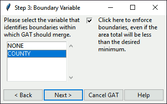
Figure: Dialog to select your boundary variable
Select your desired boundary variable. If you do not want to include a boundary, select "NONE". If you want to enforce the boundary, check the box on the right as shown. Then click on one of the following buttons.
Click
Nextto continue to the next step.Click
Cancelto end GAT.Click
Backto return to the previous step.Click
Helpto get further guidance and open this manual.
identifyGATboundary(
  shp,
  step = 3,
  boundary = "NONE",
  myvar = "NONE",
  borders = FALSE,
  check = FALSE,
  backopt = TRUE
)
Arguments
- shp
Spatial layer.
- step
Integer step in GAT, for help reference.
- boundary
Boundary variable, if pre-selected. Defaults to "NONE", which means no boundary selected.
- myvar
Boundary variable, if pre-selected.
- borders
Boolean denoting whether to enforce boundary. Default is FALSE.
- check
Checkbox setting, if pre-selected. Currently does not do anything.
- backopt
Boolean denoting whether to include the back button.
Details
This function reads in a dataset and extracts the names of variables that are (1) character and (2) not unique, since only these variables will be suitable for defining larger geographic areas in GAT.
Examples
if (interactive()) {
# select boundary variable
identifyGATboundary(shp = hftown)
}
#> $myvar
#> [1] "cancel"
#>
#> $check
#> [1] FALSE
#>
#> $threshold
#> [1] 0
#>